Thursday, April 1, 2010

Deltas

Arcuate Delta: A landform that is created at a mouth of a river where the river flows into a larger body of water.This kind of delta is bent or curved with the convex facing the body of water.Birds Foot Delta: A delta with many long projecting distributary channels, that span out like the claws of a birds.
Cuspate Delta: A tooth shaped delta where one dominant river pushes the delta forward into the body of water, and waves cause it to form into two curving beaches on either side.


Erosion Processes and Sediment Transport

Headward Erosion: A process of erosion that lengthens a stream, a valley, or a gully at the head and enlarges it drainage basin.

Vertical Erosion:
Erosion that is aiming to get to the base level and not to flow forward.

Lateral Erosion: Erosion that aims to widen the valley.

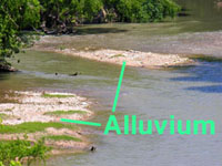
Alluvium:
Sediment (gravel, sand, silt, clay) deposited by running water.

Undercut Banks/ Slip-Off Slopes:
A bank that has had its base cut away either by water or human construction. It means that it has quite a heavy over hang that is very weak and often breaks away.


Traction/Saltation: The friction between a something and the surface it moves on. The leaping of sand or soil particles as they are transported in a fluid over an uneven surface.

Abrasion/Corrasion: Erosion through friction. Wearing away similar to that of sanding something.

Attrition: As rocks are being moved by water they bump and grind into each other causing them to break into smaller particles.

Levees: Sediment that is formed in mounds along a stream's banks.

Corrosion:
The disintegration of an engineered material back into its original state due to chemical reactions in its surroundings.

Hydraulic Action:
The force exerted by water. It works along the banks of streams attacking and undermining layers of rocks and soil.

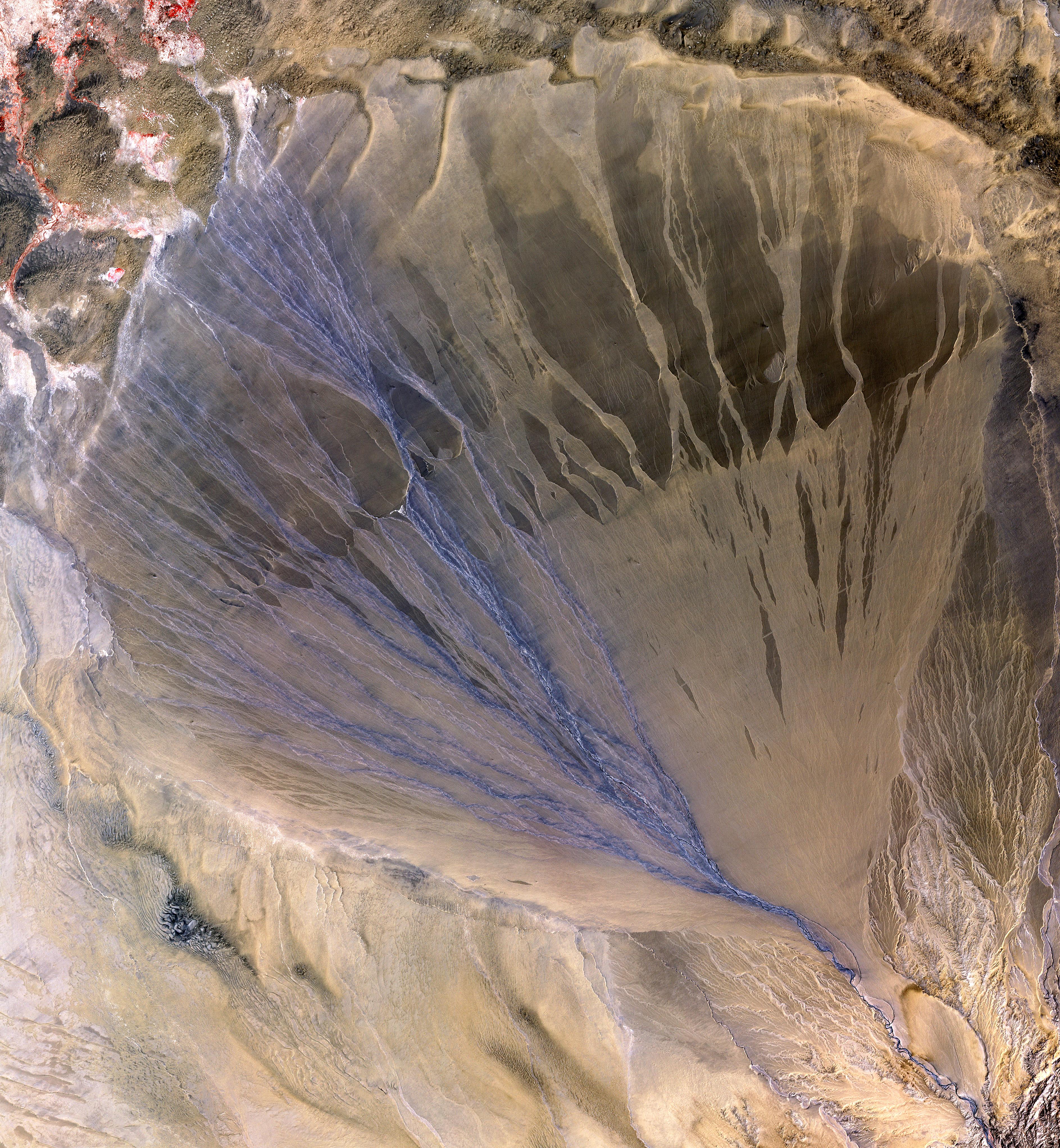
Alluvial Fan:
A fan shaped deposit that occurs when a stream slows down, flattens, and spreads usually at the end of a canyon onto a flatter area.

Hydrologic Cycle


Hydrologic Cycle:
The water cycle describes the continuous movement of water on, above, and below the Earth's surface.

Evapotranspiration:
The sum of evaporation and plant transpiration from Earth's land surface to the atmosphere.

Precipitation:
Any product of the condensation of the water vapor in the atmosphere being pulled down by gravity to the Earth's surface.

Condensation:
The change of a gas into liquid droplets.

Evaporation:
The process of a liquid turning into a gaseous state, such as what happens when water is boiled and vapor rises.

Transpiration: Similar to evaporation however the loss of water is in the leaves, or roots of plants.

Run Off:
Water flow that occurs when the ground has soaked in as much as it can and water can not be absorbed anymore.

Solution: A homogeneous mixture of two or more substances.

Suspension:
A mixture where fine particles are suspended in a fluid by their buoyancy.

Tuesday, March 23, 2010

Famous Mass Wasting Events

Frank Slide, Alberta

Location: The Southern section of the Rocky Mountains, near the border of Alberta and British Colombia on Turtle Mountain. The nearby town of Frank was bustling at the time due to the opening of a coal mine at the base of the mountain in 1901. The mountain was also famous for the native lore that surrounded it, and it got its name from the slow rock movement that the natives believed was occurring on it.

Cause: The base of the mountain is made up of coal and rock fragments, and the surface if limestone and dolomite. Over a very long time water began seeping into the cracks at the base of the mountain causing it to become very unstable.

Occurrence: The Frank Slide happened on April 29, 1903 at about 4:10 am. The East side of the mountain gave way causing large slabs of rock to tumble into the valley. The dimensions of the section of rock that fell was 150 meters deep, 425 meters high and one kilometer wide. The rocks slid 701 meters down into the valley and covered it in about two square miles of rock.

Damage: - caused a blockage of the Crowsnest River creating a lake
- bridges across Gold Creek and Old Man River were destroyed
- two miles of the CPR was covered and was not back in operation until a month later
- the entrance to the coal mine was buried, miraculously 17 miners were able to find there way out within a day
- seven houses were buried, outbuildings were destroyed, and many tents providing temporary housing were wiped out
- the town's power plant and cemetery were buried
- a construction camp and town car were also buried
- 76 people were killed, 24 people in the path of the slide survived, only 12 bodies were recovered

Aftermath: The South part of the town of Frank was forced to be closed down by the government in 1911. In 2005 a permanent monitoring station was built for the movement of the mountain. In 1985 an interpretive center was built for people to learn about the slide.

Hope Slide, BC


Location: On Johnson Peak, 12 miles South of the town of Hope, BC. Hope is East of Vancouver where the Fraser valley meets the Coast Mountain range.

Cause: A first earthquake at a about 3:56 am on January 9, 1965, three hours later another earthquake occurred causing the slide.

Occurrence: The first earthquake caused a small avalanche that blocked off the highway in the area. Due to the fact that there was so much snow at that time of the year no one predicted that the whole rock face of the mountain was going to come tumbling down. Three hours later the entire southeast slope of Johnson Peak came tumbling down. About 60 million cubic yards of rock, snow, mud and trees tumbled 6000 feet into the valley below. The depth of the debris was about 200 feet.

Damage: - Outram Lake was obliterated
-two miles of highway was covered
-four people were buried, but only two of four bodies were found

Aftermath:
Since the rocks were too deep to move they had to rebuild the highway around it, yet since the mountain was in a more remote area then the Frank Slide there was not too much damage that had to be repaired.

Portuguese Bend, California


Location: The Palos Verdes Hill in California. Part of a peninsula.

Cause: A housing development that began in the 1950's, and a road that was built. Also due to the fact that pools, and underground pipes were constructed it meant that the ground had increased water levels.

Occurrence: The first signs of the slide was on August 17, 1956. Cracking was occuring in buildings around the area and although the cracks were repaired they all showed up again a couple days later. Soon the cracking began to go onto the road as well, and soon after that distortions in the road were also visible. Every day there would be about 7-10 cm of movement. The movement and sliding effected about 80 acres of land, much of it being residential areas.

Damage: Although no one died, many had to leave their homes and a lot of construction work had to be done in order to repair the damage.

Aftermath: All water lines have been moved to the surface in order to not increase the amount of water in the ground, and people no longer live in the area.

Causes and Solutions to Mass Wasting

CAUSES

Shocks: A sudden shock, like that of an earthquake may trigger a slope to become more unstable. Even more minor shocks such as a truck rolling down the road or heavy winds can cause things to get unsettled.

Slope Modification: Sometimes the amount of slope can be modified by either humans or natural causes and this can cause either more or less mass wasting to occur.

Undercutting: When a stream or river cuts away at a slope causing it become unstable.

Precipitation: In some cases rain is minor and only causes little change, or moves soil so that it may move in the future, in other cases where the rain is quite major then it can cause large amounts of mass wasting.

Volcanic Eruptions: Due to the fact that they both shock the Earth, and molten lava causes things to move. As well as it can melt ice causing a lot of water to flow, causing things like land or mud slides.

SOLUTIONS

- not undercutting at the base of slopes
- not adding heavy weight to the top of slope
- not removing vegetation and roots that keep soil in place
- trying not to saturate the soil with too much water
- building barriers and retaining walls
- drainage pipes for excess water
- terracing slopes so that they are not so steep
- planting more grass and other plants
- putting up rock cables and screens so that there can not be rock falls

Monday, March 22, 2010

Types of Mass Wasting

Soil Creep: Occurs on slopes, especially in humid areas. A slow movement of loose rock and soil down a slope. Hard to observe it happening, but you can tell that it occurs because of the tilt of fences, walls and curved tree trunks. It can be assisted by freezing, thawing, wetting and drying.

Slump: When a block causes large amounts of rock to slowly move down a hill.

Solifluction: Common in warm, moist climates. Movement of land like a thick liquid. A slow, downhill flow of rock and soil that have been saturated with water.

Flows – Earth Flow, Mudflow: A rapid movement of a large mass of mud formed by water and soil.

Talus Creep: Fan shaped pile of rubble formed by a fall.

Slide –Rockslide: Occur when large sections of rock break loose and rapidly slip down to the base of a slope.

Avalanche: A rapid flow of snow, ice, earth and rack masses.

Fall : Rock fall: When individual rocks fall down a slope creating a fan shaped pile at the bottom of a slope.

Thursday, February 11, 2010

Earthquakes, Folds and Faults

1. Explain the relationship between earthquakes and plate tectonics. Why do earthquakes occur at places NOT on plate boundaries ?

Earthquakes happen on the earth were ever there has been enough stored up elastic strain energy to drive factures along a fault plane. As the plates are moving past each other sometimes they lock and this causes them to build up tension until they finally force past each other and cause shaking or earthquakes. When this happens within the continental lithosphere sometimes the plate deformation is spread out over a larger area then the plate boundary itself. The earthquakes away from the plate boundaries are caused by the fact that strain occurs in these continental deformation.


2. Normal Fault:
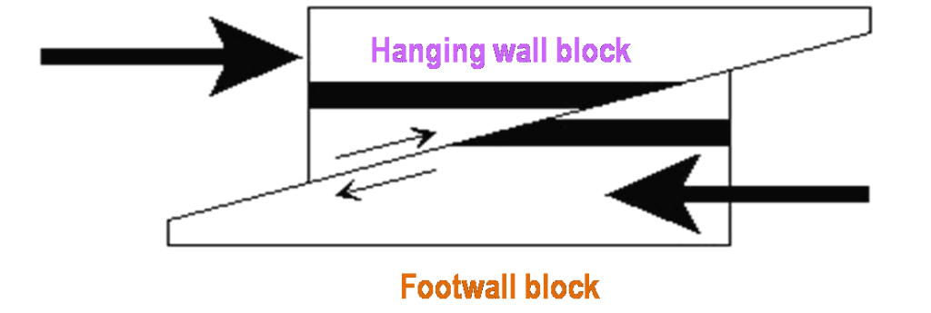
Reverse Fault:

Overthrust Fault:

Transform Fault:
3. Describe the dangers associated with earthquakes.

The effects of earthquakes are many including:
Shaking and Ground Rupture: Depending on the strength of the earthquake and how close you are to the epicenter this will have different effects. Sometimes you may just feel minor shaking and other times whole cities can be destroyed. On occasion there is visible breaking of the earths surface, which could cause severe damage as well. Most of the time however they have learned where this breaking would occur and make sure to build nothing major in these areas.
Landslides and Avalanches: On steep slopes earthquakes can often cause rock and snow to fall and collect taking anything in its path with it.
Fires: Because of the fact that it causes the earth to shake if often causes power lines to break and this can cause fires in large cities.
Soil Liquefaction: Because of the shaking of the earth it can sometimes cause solid ground material to turn to more of a liquid, and this can cause buildings to sink.
Tsunami: When there are large earthquakes under the ocean it causes large, long period waves to come to the surface. Where there are cities near the ocean this can be devastating.


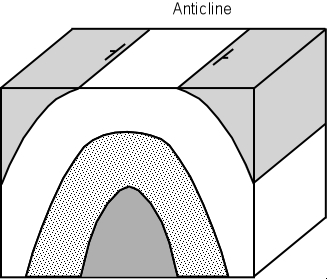
4. Anticline:
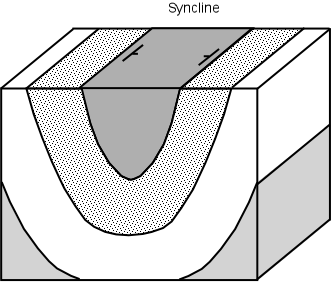
Syncline:

Dome:

Geosyncline:
http://www.geology.ohio-state.edu/~vonfrese/gs100/lect21/xfig21_02.jpg