Thursday, April 29, 2010

Frontal or Cyclonic Rainfall


ADVECTION FOG: Occurs when moist air passes over a cool surface via wind and is cooled. It is most common at sea when the tropical air collides with the cooler waters.

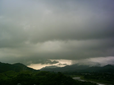
RADIATION FOG: Occurs as a ground fog. It is caused be the radiation cooling of the Earth's surface, and often only occurs at night time. It will never form over a water surface, and often covers a very side area. The radiation causes the lower air to be heated causing evaporation of the lower part of the fog and giving it the appearance of lifting. It is common in high pressure areas and where there are clear skies.
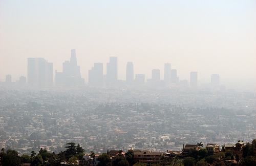
SMOG: A kind of air pollution, meaning both fog and smoke mixed together. It often comes from the emissions of both vehicles and factories. It is also caused by large amounts of coal burning and mixing with smoke and sulfur dioxide.

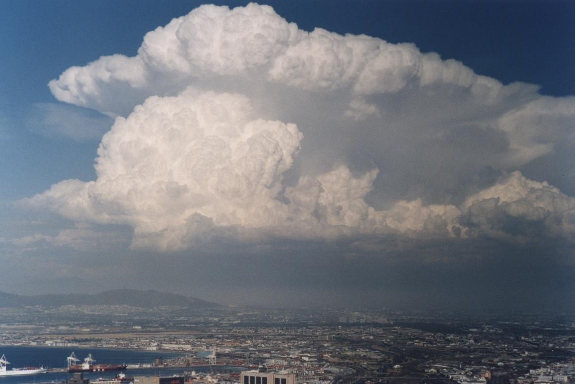
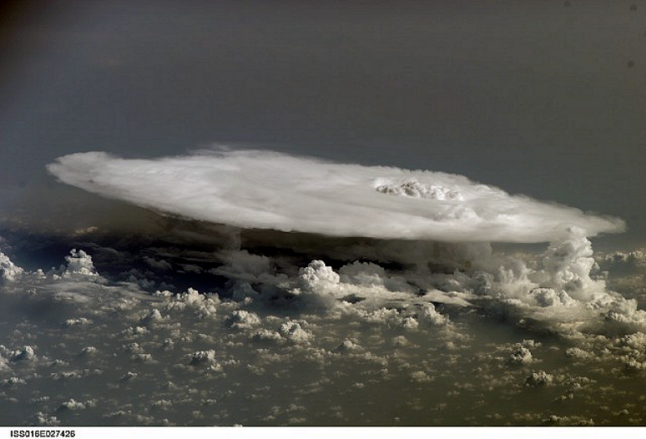
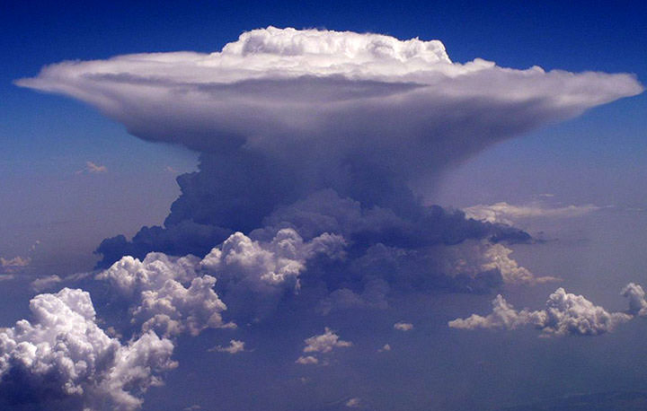
HURRICANE: A storm system characterized by a large low pressure center and accompanied by thunderstorms, strong winds, and heavy rain. They feed on the heat that is released when moist air rises, causing the condensation of water vapor in moist air. They originate near the equator and often only happen in tropical areas. Though they produce strong winds and rain they are also able to created high waves, and tornadoes. They develop over large bodies of warm water, but begin to lose their strength as they move over the land, meaning that areas close to the coast often receive the most damage. They are very damaging to populations however they can also be quite beneficial to drought situations. They can also help carry heat and energy away from the tropics and move it to temperate latitudes, making it an important part of circulation in the atmosphere and maintaining the equilibrium in the troposphere.
CYCLONE: An area of closed, circular fluid motion rotating in the same direction as the Earth. This means that they moved counter clockwise in the Northern Hemisphere and clockwise in the Southern Hemisphere. They often occur in areas of low atmospheric pressure, and their center is the area of lowest atmospheric pressure in the region.
TYPHOON: A non-frontal, low pressure system over tropical waters in the Northwest Pacific Ocean. They form in the Pacific Ocean, and if they cross the date line they become known as typhoons, otherwise they are known as hurricanes. Most of these storms occur between May and November however it is possible for them to happen all year long.

TORNADO: A violent, rotating column of air which is in contact with both the surface of the earth and a cumulonimbus cloud. They can come in all shapes and sizes but are often in the form of a visible funnel, whose narrow end touches the earth. It is often encircled in a cloud of debris and dust.

Orographic Precipitation

OROGRAPHIC UPLIFT: Occurs when air is forced to rise and cool due to features such as hills or mountains. If the cooling is enough then water vapor will turn into clouds, and even more cooling can result in rain or snow. This means that there are often more clouds and rain or snow in higher regions.

ADIBATIC HEATING: Is a change in temperature due changes in the pressure of a gas while not adding or subtracting any heat. Adibatic heating occurs when the pressure of a gas is increased. It is common in convective currents in the atmosphere. As a mass of air descends in the atmosphere, such as when it moves downslope on a mountain range, the air encounters increasing pressure. Compression of this air mass means an increase in temperature.

CHINOOK WIND: Along the eastern slopes of the Rocky Mountains the Chinook wind is a lovely warm breeze during the winter season. These winds are caused by most weather patterns coming from the Pacific coast, cooling as they climb the western slopes of the mountain and then quickly warming as they come down the eastern side. They often begin with a sudden change in the direction of the wind towards the west and in increase of the speed of the wind.

WINDWARD SIDE: The side of something such as a mountain or hill that is facing the wind. The direction the wind is blowing towards.

LEEWARD SIDE: The side of a hill or mountain that is sheltered from the wind. The direction in which the wind is blowing.

RAIN SHADOW: A dry area on the mountainside that is facing away from the direction of the wind. A mountain or hill blocks the passage of rain producing clouds causing a "shadow" or dryness to follow behind them. This occurs because as warm moist air rises to the top of a mountain it cool and rains on the top of the mountain. Then as the air comes back down it has lost all of its moisture and has no more to precipitate.

Convectional Rainfall


CUMULONIMBUS CLOUD: These occur at the same heights and with the same vertical growth as the cumulus clouds. These are towering thunderheads that bubble up through the troposphere. Due to the fact that they reach freezing altitudes they often become “crowned” with a giant feathering anvil top of ice crystals. They will produce heavy rain, thunder and lightning.

ANVIL TOP: The upper part of a cumulonimbus cloud that flattens and spreads out when it meets the troposphere. Usually of a fibrous or smooth appearance.

CONVECTIONAL OVERTURNING: The outer shell of a cumulus cloud is often quite stable and the pattern of it is very clear cut, because of the result of mixing cloud and unsaturated air. Toward the center of the cloud there is instability, due to mixing and increasing water content. The rate at which the mass of air in a cloud increases equals the rate of entrance through sidewalls and top, meaning the amount of air that goes in and out must be equal.

CONVECTION CURRENT: A current caused by the expansion of in this case a liquid as the temperature rises. The expanded material being less dense rises while the colder material will sink. They occur in the atmosphere above warm land masses or seas giving rise to sea and land breezes.

THUNDER: The sound of lightning, and depending on the distance or the the nature of the lightning the sound can either be a sharp loud crack, to a low long rumble. The quick increase in both temperature and and pressure from lightning creates rapid expansion of the air and this expansion creates a sonic shock wave. You can calculate the distance of lightning to you by the time between and the flash of light and the sound that follows.

LIGHTENING: A discharge of electricity in the atmosphere. In order to create lightning there must be a build up of about 300 million volts in the cloud. The earth becomes positively charged under a storm cloud and eventually a spark jumps, between the negative charge of the cloud and the positive charge of the land, in a series of jerky steps.

Wednesday, April 28, 2010

Clouds


STRATUS: The base of these clouds can occur anywhere from almost ground level to about 5000 feet. They are rather dark and often have many layers with broken patches called fracto-stratus. It is quite thin and will really only produce a drizzle.


CUMULUS: These clouds often extend vertically quite high. The base can be anywhere from 1600 to 35000 feet. They are thick bubbling clouds with flat bases. Often blue sky surrounds them. They will not produce precipitation.

CUMULONIMBUS: These occur at the same heights and with the same vertical growth as the cumulus clouds. These are towering thunderheads that bubble up through the troposphere. Due to the fact that they reach freezing altitudes they often become “crowned” with a giant feathering anvil top of ice crystals. They will produce heavy rain, thunder and lightning.


NIMBO STRATUS: These type of clouds occur close to the surface of the Earth. It is often thick, enough so that ice crystals can form but it will not produce precipitation.

CIRRUS: These clouds are formed at above 20000 feet and because of the low temperatures are formed completely out of ice crystals. They are thin, feather like wisps, often streaming with the wind. They will not produce precipitation.

ALTO: These clouds range from 6500-20000 feet and are composed of water droplets. They can either be large puffs like cotton, rounded in appearance and appearing in bands like the alto-cumulus. Or they can be a thin layer of cloud, that is grayish blue as in alto stratus. They do not produce much precipitation.

Thursday, April 22, 2010

The Atmosphere

Troposphere: Contains 75% of the atmosphere's mass and 99% of the water vapour and aerosols. The average depth is about 17 km, however in tropical areas of the Earth it is around 20km, and in the poles it is closer to 7 km. Most weather conditions occur within this region of the atmosphere. The temperature drops quite drastically the higher up you go in the troposphere as well as the density and the air pressure.

Stratosphere: Right above the troposphere and extends to about 50 km. It is both drier and less dense then the troposphere. This is often where flying equipment reaches its height. There are very few to no clouds in this region due to the lack of water vapour. Due to the lack of vertical convection in this layer it means that chemicals often stay there for very long periods of time.

Ozone Layer: The ozone layer if made up of three oxygen molecules, unlike the air that we breathe in which is made up of only two. When enough of these molecules are present it causes a pale blue gas to form. It has the same chemical structure in all layers of the atmosphere however depending on its location it is either good or bad ozone. The bad ozone occurs in the troposphere. It is an air pollutant that damages humans, vegetation and other materials. In the stratosphere is the good ozone which protects the life on earth from harmful UV rays. There is much worry about the build up of bad ozone, and the deteriorating of the good ozone.


Thursday, April 15, 2010

Desert Landforms

Wadi: An arabic term that refers to a valley. In some cases it can also refer to a dry riverbed that only experiences water when there is a heavy rain fall. Unlike other valleys a wadi has been cut and eroded by water however because it is in desert it rarely experiences any constant water except for during the rainy season. Deposition is very common in a feature such as this because of the fact that the water dries up and is no longer able to carry a load of sediment that it has.

Playas: An area of very dry land that is found below the sea level. Flats like this often consist of fine grained sediments such as salts. During the dry season the surface of the lake is usually hard and rough, where as in the rainy season it gets wet and soft. The water usually creates a small hole meaning there is a very shallow lake in the desert.


Alluvial Fans: Often found in the desert where periodic flash floods occur. They often have a large funnel shaped basin at the top which then creates a very narrow stream which then opens into an alluvial fan at the end of its course. These alluvial fans are often home to much more life and plants then the rest of the desert due to the fact that any nutritional sediment and water will end up here.

Bajada:
When many alluvial fans all come together in one place, or deposit in the same area it creates a bajada. Because of the gathering of all the fans it means that there is much more water and sediment then usual, and it is quite evenly spread out throughout the whole bajada.


Mesa: An elevated area of land that has a very steep sides and a flat top. They are formed by the weathering and erosion of horizontally layered rocks that are lifted by the tectonic activity of the area. Due to the fact that some rocks erode faster then others, or others are stronger it means that stronger rocks usually make it to the top and the weaker rock is at the bottom.

Butte: An isolated hill with very steep sides,
and a small somewhat flat top. Typically they say that a mesa has a top wider then its height and a butte has a height larger then its width.


Canyon: A deep ravine between cliffs, often carved into the landscape by a river. They are formed when there is stronger rock on either side of where the water is eroding. This means that the water is able to cut vertically but not horizontally.


Deflation Hollow or Basin: Created by wind action. Fine grained particles from rocks that are easily weathered are carried away creating a hollow. As the hollow deepens they collect water during the rainy season. This water helps speed up the weathering of the rock creating more particles to be blown away by the wind. Due to this the hollow is able to deepen faster then the rest of the land surrounding it, creating a large hole in the ground.

Barchan: A sand ridge in the shape of an arc. Wind can often push the dunes through the desert, and they can stretch in size anywhere from a few meters to hundreds of meters long. They occur in the opposite direction of the parabolic dunes and have their steep slip face on the concave instead of the convex of the dune. Its extend arms are in front of it instead of behind it.

Parabolic Dunes: U or V-shaped mounds of sand that has an elongated arm that extends upwind. They are always associated with vegetation which help anchor the trailing arms of the dune. They are found in areas where the wind only blows in one directions. Slip faces occur on the outer size of the dune and on the slops of the elongated arms.


Pedestal Rock:
A large bolder on top of a very narrow base. This occurs when there is soft rock underneath that is easily eroded and harder rock on top that can not be eroded away.


Arch: Formed where there is soft rock surrounded by hard rock. Deep cracks penetrate into the sandstone layer and erosion wears away exposing the rocks layers and enlarging the surface cracks. Softer rock gets broken away by wind and the little amount of rain forming arches where the soft rock being broken away creates a hole in the harder rock.

Salt Flats: Formed where there are dry lake beds. It is an area of very dry land that occurs below the sea level. It receives much of the sediment that is deposited. In the case of a salt flat this if often salt deposits that are left in a large dry lake bed.


Badland: Form where deep beds of easily eroded rock is exposed to erosion. The infrequent heavy rains are able to cut out stream channels. This results in gullies, carved hillsides and tall spires of the most resistant rock to erosion.


Despite the lack or limited amount of precipitation in deserts, water is the major agent of erosion. Rainfall when it comes is brief and intense, and due to the hard rocky surface and limited vegetation tends to RUN OFF, creating FLASH floods. Because of limited precipitation PHYSICAL weathering is dominant. The main physical processes are HEATING-COOLING ,FREEZING-THAWING, and EXFOLIATION. Despite the fact that water is the most important agent of erosion in deserts, wind is quite important too. The action of wind eroding, transporting and depositing sediments is called EOLIAN processes. Wind erosion is common because there is little VEGETATION to hold the sand or sediment in place. Deflation is the large scale removal of sediment by wind. Abrasion is the process where sand carried by the wind “sandblasts” rocks. Regions covered in sand are called SAND SEAS or ERGS. Regions which are bare rock are called DESERT PAVEMENTS or REGS in Algeria.


Longshore Drift and Headward Erosion


Longshore Drift: The transport of sediments, such as sand and gravel, along the coast at an angle to the shore which depends on the wind direction, waves and the backwash of waves. The initial waves moves sediment up the beach, then the backwash pushes it back down the beach. This creates a zig-zag movement of sediment on the coast. Large sediment is found updrift and the smaller sediment which is more usually moved is found downdrift.

Headward Erosion: Backwards erosion of material at the start of a river or stream. Gravel or soil at the source of the river are carried away causing the start of the river to move backwards as erosion takes place in the opposite direction of the flow of the river.


Tuesday, April 13, 2010

Coastal Landforms: Depositional Features

Wave Built Platform:
A terrace on the seacoast, formed by the merging of a wave-built terrace and a wave cut platform. An embankment of loose material on the coast.


Spit:
At one end spits are connected to the land, and on the other hand they are in open water. They are formed by the movement of sediment, usually sand, along the shore by the process of longshore drift. When the wave is no longer able to carry the load of
sediment then it is deposited in the form of a spit.


Barrier Island:
A coastal landform and type of barrier that are narrow strips of sand that run parallel to the land. They often occur in chains of many islands. Like spits they are formed by the dropping off of sediment.


Tombolo:
An island that is attached the mainland usually by a small strip of land such as a spit. When many of these islands are linked together then it is called a tombolo.


Bar:
An elevated reigon of sand or gravel that has been deposited by the flow of the ocean. There are many different kinds and they are often connected to things such as tomobolos or barrier islands.

Coastal Landforms: Erosional Features


Wave Cut Platform:
A narrow flat area found at the base of a sea cliff or along the shoreline or a body of water. They are often only visible at low tide, appearing as large areas of flat rocks. They are created by waves
undercut
ting a cliff, eventually it cuts so deep that the cliff is not able to support itself and breaks away creating a flat area.


Sea Cliff:
A significant vertical, or close to vertical rock exposure. They are often found on the coasts and occur where the rock is not prone to, or is strong against erosion and weathering.


Sea Cave:
A cave formed by the wave action of the sea. In order to form the cave the rock must have a weak zone. Rock is then eroded at a faster rate, however because the rest of the rock cliff is strong it is able to support the weight. Because of the confined space that the waves are often eroding it becomes stronger and more powerful and is able to go deep and far into the rock.


Arch:
Erosion from the ocean finds weak parts in the rock and cuts away at it creating a natural arch way under the rock. The strength of the rock means that it is able to maintain its shape, however erosion and weathering also cuts at the side meaning the support can be quite thin.


Stack:
Rock formation that stands alone and is no longer attached to a cliff. Like sea caves and arches the ocean works away at the weak part of the rock slowly breaking it free from the cliff it was once a part of. It usually begins as a cave in the rock, which then becomes an arch due to more erosion, and when finally the rock can not hold and breaks away it becomes a stack.

Monday, April 12, 2010

Oceans


Ocean Currents
1. Currents are the transfer of vast quantities of water from one place to another. The most obvious cause of the currents is the air above the oceans. Winds literally push waters along by catching on to waves ad ripples of the ocean. Another cause of ocean currents is the difference in temperature from the water at the Equator and the water that is further North and South. This causes the water to move in a gyre, or a circular motion, clockwise in the Northern Hemisphere and counter-clockwise in the Southern Hemisphere. Another cause for this gyre movement is Coriolis Force, or a deflective force caused by the rotation of the Earth. The last cause for the currents in the ocean is the salinity or the saltiness of the water, causing more dense water to flow in currents.

2. Peru Current on the Coast of Chile: This current causes for the coast of Chile to have the most abundant fish population of anywhere in the world and about 18-20% of the worlds fish catching comes from this area. It also causes for the temperature of Chile to not be over heated, and for their to be some cooler areas.

Gulf Stream on the weather conditions in Newfoundland: Warm surface waters always move into colder latitudes, and then return from polar ares in the form of strong currents such as the Labrador current off the coast of Eastern Canada. This current slips under the Gulf Stream, which is always warmer then the surrounding waters. Because of this difference in temperature from the climate of the landscape and the water the Earth's temperature is able to be regulated. If not for currents like these then the polar reigons of the Earth would get MUCH colder and the tropical environments would get MUCH warmer.

Tides

1. Causes: Tides are influenced by both the gravitational pull of the sun, and more strongly the pull of the moon. When the moon is overhead it pulls the water toward it, causing more water to go to one side of the Earth, or a high tide. As the moon goes around the world in a day, it pulls the water with it. When the sun and the moon pull the water in the same direction it causes for a very high tide, or a SPRING TIDE. When the moon and the sun pull it from both directions then it causes for a low - high tide or a NEAP TIDE.

2. How are Tides Beneficial?
-High tides are used to drive turbines and to produce electricity in some areas of the world.
-Boats are also able to use the changing of the Earth's tide to their advantage and make it more easy for them to travel the world.
- When the tide comes in it brings with a variety of marine life, meaning for good fishing.


Wednesday, April 7, 2010

Groundwater and Aquifers

Importance of Groundwater in my Community, Canada, and the World:

Community: The province of British Colombia has 28.5% of the population using groundwater for domestic purposes.
Canada: 8.9 million or 30.3% of the population rely on groundwater for domestic use.
The World: 20% of the world's fresh water supply.

Artesian Well:


A contained aquifer containing groundwater that will flow upwards through an artesian well without the need of any pumping. An aquifer is a layer of soft rock that absorbs water. The water is under extreme pressure so when an artesian well is built then it means that the pressure will force the water to flow up instead of down, defying gravity.


Man's Impact on Groundwater and Aquifers:


Ogallala Aquifer: Covering an area of 450 000 square km, it is one of the world's largest aquifers, located in the Great Plains of the US. It yields about 30% of the groundwater used for irrigation of farms, as well as 82% of the water used for drinking in the area.
Urban Water Cycle: A project with countries around the North Sea working to develop solutions to their water problems. Holland, Germany, England, and Denmark all share their ideas on how they sustain and provide water for their countries, and together by sharing their ideas and seeing what has been working and not working they are developing the best way to sustain and use the water we have in the world.
Walkerton, Ontario: In May 2008 the water supply of Walkerton, Ontario was contaminated with the E.coli bacteria from farm run off into an adjacent well. Half of the population of the small town of 5000 became ill from the water, and 7 died due to the fact that the city did not admit to the problem earlier on.
Impacts in Canada: Things such as septic systems, leaky tanks or pipes, spills of chemicals, landfills, livestock waste, graveyards, and chemicals used on farms all have an impact on the safety of the ground water in Canada. Some contamination can be so bad that the groundwater can be completely unusable, which obviously has a large impact on Canada seeing that many people rely on it for their water needs.

Thursday, April 1, 2010

Stream Cycle


Youthful Stream
Youthful Stream: A steep gradient, and a fairly straight channel. For the most part it flows in a V-shaped valley in highlands of mountainous areas with very little shifting of its channel. It reaches quite high speeds, and it works at lowering its channel through downcutting so that it can reach the base level. It has a very little floodplain, and rapids and waterfalls may be on its course.

Mature Stream

Mature Stream: A stream in its middle stage has a medium gradient and speed because it has eroded the bed downward and gotten closer to the base level. Though it is still eroding downwards it mainly erodes laterally.

Old Age Stream
Old Age Stream: A stream that has nearly reached the base level. Its gradient and speed are very slow, and because of this it has lost the power to erode downwards. It deposits as much as it erodes, and has a wide well developed floodplain defined by oxbow lakes.

Flood Plain: Flat land adjacent to a stream or river created by the stream flooding over and leaving deposits of rock and soil. This land often experiences flooding.

Oxbow Lakes: A U-shaped body of water that has been formed when a wide meander of a stream or river is cut off to create a lake.

Stream Rejuvenation


Paired Terraces: A terrace on the same level of either side of a stream or river. This occurs when the water downcuts evenly on both side of a valley.

Meander: A bend or a loop in a streams course

V-Shaped Valley: An erosional feature created by a stream. A stream erodes a fairly narrow path through the landscape, often trying to get to the base level. If the rock it is cutting through is weak and breaks away easily then it will most likely cause a steep v-shaped valley with more rock cut away at the top and less at the bottom.

Interfluve: A region of higher land between two rivers that are in the same drainage system.

Divide: A division or split of a drainage system by higher land that causes them to drain into different bodies of water.

Parts of a Drainage Basin/Watershed

Water Shed: A piece of land where water from rain and the melting of ice drains into a larger body of water. Includes the streams, rivers and channels.

Tributaries: A stream or river that flows into a main or parent river. It does not directly flow into a large body of water like an ocean or lake, but instead connects up to a river that does.

Distributaries: A stream or river that branches off of the main or parent river. It then can lead to a larger body of water, or in some cases it might steal so much water from the parent river that it becomes the main.

Yazoo Streams: A stream that runs parallel to a river, and eventually joins up to it.
Confluence: The meeting of two or more bodies of water. It usually refers to the tributary of two rivers or streams meeting up but sometimes it can be two channels, or a channel and a lake.

Estuary: A partly enclosed coastal body of water with one or more rivers flowing into it and an open connection to the sea. It is prone to both ocean and river influences.

Braided Stream: A stream with many small shallow channels that divide and recombine many times creating a braided pattern. They form when a sediment load is too heavy and it has to be deposited along the channel.

Groundwater: Water that is located beneath the surface of the Earth in pores in the soil.

Drainage Patterns

Trellis: A type of drainage system. As a river flows down a valley, smaller tributaries flow into it from the slopes of mountains at a 90 degree angle causing it to have the trellis appearance.

Radial: A type of drainage system. Streams radiate outwards from a high central point. Volcanoes often have this feature.


Dendritic:
The most common form of drainage system. Form in v-shaped valley where many small tributaries join together and then join onto a main river, giving it the appearance of a tree.

Deranged: A type of drainage system with no coherent pattern or system. It occurs where there has been much upset or disruption of the surrounding area.